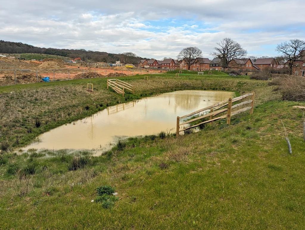

Legal & General's outline plan for Mowbray, north Horsham: up to 59,416 sqm of workspace, 977 jobs forecast, buildings to 16m. Comments close 15 September.
Plans for the business end of Mowbray, the 2,750-home scheme north of Horsham, are now open for comment. Legal & General has applied for outline permission to build an employment park on 17.21 hectares beside the A264, with warehouses, offices, a health centre and a commercial leisure building. Comments close on Tuesday 15 September 2026.
The application is reference DC/26/1240. It was received on 3 August and validated on 25 August (Horsham District Council planning register). The case officer is Jason Hawkes. The agent is Stantec UK Limited.
This is an outline application with all matters reserved. That means the council is being asked to agree the principle and the maximum scale, not the design. Layout, appearance and landscaping would come back later in reserved matters applications.
Three options, one permission
The applicant is not asking for a single scheme. It wants consent for a flexible mix that could be delivered in any of three ways, depending on demand. All three are set out in the Environmental Statement submitted with the application.
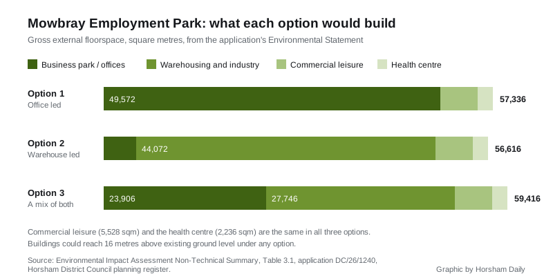
The floorspace figures below are gross external areas, taken from Table 3.1 of the Environmental Impact Assessment Non-Technical Summary:
- Option 1, commercial office led. 49,572 sqm business park, 5,528 sqm commercial leisure, 2,236 sqm health centre and pharmacy. Total 57,336 sqm.
- Option 2, warehouse led. 44,072 sqm of B2 and B8 industrial and logistics, 4,780 sqm business park, 5,528 sqm commercial leisure, 2,236 sqm health centre. Total 56,616 sqm.
- Option 3, a mix. 27,746 sqm of warehousing, 23,906 sqm business park, 5,528 sqm commercial leisure, 2,236 sqm health centre. Total 59,416 sqm.
Every option is assessed on the basis that buildings could reach 16 metres above existing ground level. The document says that is no change to the height already assessed for the wider scheme.
The leisure and health buildings are fixed to the western parcels near the A264 access. A 2.49 hectare parcel is earmarked for indoor sport, recreation or fitness. A smaller 0.72 hectare parcel would take medical or health services. A 1.88 hectare strategic green buffer south of the railway stays as natural greenspace.
What it means for jobs
The applicant’s own socio-economic assessment tests Option 2, the warehouse-led version, because that is the worst case for this topic.
It concludes the employment park would support 977 full-time jobs, an increase of 1.3% in the number of jobs in Horsham district. That is recorded as a moderate beneficial and significant effect. The assessment is explicit that this is fewer jobs than the business park it replaces was expected to generate.
Not all of those jobs would go to Horsham residents. The net additional employment effect for the district is put at 660 full-time equivalent jobs, a 0.9% rise in resident employment, described as minor and not significant. Annual economic output is forecast at £43m, about 1% of district output.
For context from the same document, Horsham district had 151,500 residents in 2024 and is a net exporter of labour, meaning it has fewer jobs than working-age residents.
Why a new application at all
Permission for Mowbray already exists. The council approved outline application DC/16/1677 in March 2018 for a mixed-use scheme of up to 2,750 homes, a business park of up to 46,450 sqm, retail, a community centre, leisure, education and open space. The land is allocated under Policy SD1 of the Horsham District Planning Framework 2015.
The homes are being built. The Environmental Statement records 249 dwelling completions across the early phases.
The business park is a different story. The deadline to submit reserved matters for that part has passed, so the 2018 consent can no longer be used for it. A fresh outline application is needed. The applicant says the flexible mix responds to changing market demand, and it moves the health centre and the leisure building here from elsewhere in the scheme.
The site itself
The 17.21 hectares are in five parcels, mostly farmland divided by hedgerows and hedgerow trees. Channells Brook runs along much of the western and north-western boundary. The A264 forms the southern edge. The Horsham to Crawley railway line runs between the eastern parcel and the larger central one.
Other points from the submitted documents:
- Most of the site is in Flood Zone 1, the lowest flood risk. Some land beside Channells Brook is in Zones 2 and 3, and no built development is proposed in medium or high risk areas.
- The land is likely a mix of Grade 3a and 3b agricultural quality. Grade 3a counts as best and most versatile land.
- Public footpath 1586 crosses the site from south west to north east.
- Newhouse Farmhouse, Grade II listed, stands about 120 metres to the south east. Two scheduled monuments lie about 500 metres away, one north and one south west.
- Access would come off the Employment Road, which is the subject of a separate application, DC/25/1543. A secondary link road would loop through the southern parcel, with a separate access to land reserved for a future station.
Construction is anticipated to start in 2027 if permission is granted, with the last parcels starting around 2031 and completion expected in 2032. Standard working hours would be 8am to 5pm Monday to Friday and 8am to 1pm on Saturday, with no working on Sundays or bank holidays.
The Environmental Statement finds no significant effects during construction. The only significant residual effects it identifies are the beneficial ones on jobs and economic output.
The first consultation response on the file is from Sussex Police. Its Designing Out Crime Officer wrote on 25 August that, as the application seeks approval in principle, there are no detailed comments at this stage, and asked to be consulted again at reserved matters.
What it means for you
If you want a say, the deadline for neighbour comments is Tuesday 15 September 2026. The advertisement period runs to 24 September. The council’s own determination deadline is 15 December 2026, so a decision is unlikely before the winter.
Comments can be made through the council’s view and comment on planning applications page. There is a catch. A notice on the planning portal dated 27 August says commenting without a registered account has been temporarily disabled while a technical fault is fixed. The council is asking people to register first, or to email planning@horsham.gov.uk instead. The portal also warns comments can take five to ten days to appear.
All 124 documents, including the full Environmental Statement, transport statement and flood risk assessment, are on the council’s document search for DC/26/1240.
We track what is being decided locally on our Horsham planning applications page, and current closures on the Horsham roadworks and travel page.
Have your say